School nearby ISRI - Institute Of International Relations
Mozambique
School nearby ISRI - Institute Of International Relations
ISRI - Institute Of International Relations
Maputo, Mosambik
contacts phone
:
+258 21 900 068
Latitude:
-25.8213687
, Longitude:
32.5806467
larger map & directions
read more
nearest School
1.307 km
Escola Primária Completa de Wiriyamu
Maputo
School
read more
1.78 km
Colégio Nyamunda
Maputo
School
read more
2.42 km
Ministério Arco Íris
Maputo
School
read more
3.796 km
School Magoanine B
Maputo
School
read more
3.883 km
High Institute of Physical Planning and Environment
Avenida de Michafutene, Michafutene, Moçambique
School
read more
4.176 km
Escola De khongolote
Matola
School
read more
4.485 km
Escola Secundária Bonifácio Gruveta Massamba
Matola
School
read more
4.668 km
Escola Primária Completa De Khongolote
Matola
School
read more
4.784 km
Magoanine Cmc
Unnamed Road, Maputo
School
read more
5.033 km
Community School MissãoYoido
Matola
School
read more
5.401 km
Escola Secundaria De Magoanine
Maputo
School
read more
5.53 km
Escola de Condução Sherlyzia
Unnamed Road, Maputo
School
read more
5.536 km
Escola de Condução Chambe Auto, Lda.
Avenida Nkongolote, Matola
School
read more
5.781 km
Centro De Formação Profissional Yulu
Matola
School
read more
6.513 km
Primary School Guebo
Avenida Cardeal Alexandre dos Santos, Maputo
School
read more
7.03 km
Escola Secund. de Malhazine
Maputo
School
read more
11.972 km
Mindo Macomr
Maputo
School
read more
13.115 km
Direcção Provinvial De Trabalho
Matola
School
read more
13.319 km
Kitesurf School MK
Avenida da Marginal, Maputo
School
read more
14.411 km
Escola Primaria Completa de Lhanguene Piloto
Maputo
School
read more
14.509 km
Escola Primária da Coop
Maputo
School
read more
14.592 km
ITM F
Avenida Do Trabalho, Maputo
School
read more
15.245 km
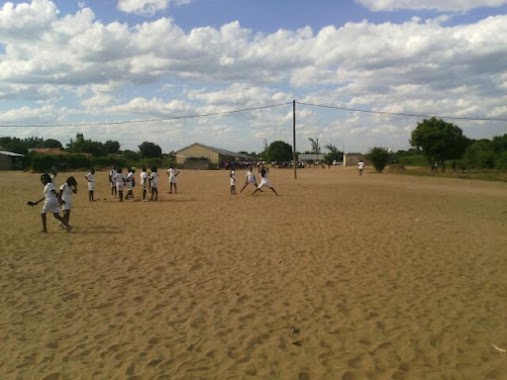
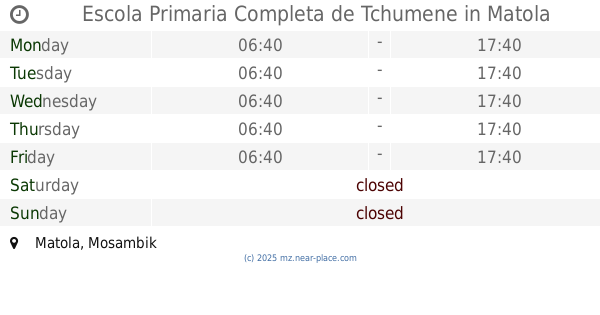
Escola Primaria Completa de Tchumene
Matola
School
read more
19.153 km
ITL
Matola
School
read more
19.33 km
Centro O Pais do Arco Iris - Comunidade di Sant'Egidio
Matola
School
read more
📑
all categories
Accounting
Administrative area level 1
Administrative area level 2
Airport
Amusement park
Art gallery
Atm
Bakery
Bank
Bar
Beauty salon
Bicycle store
Book store
Bowling alley
Bus station
Cafe
Campground
Car dealer
Car rental
Car repair
Car wash
Casino
Cemetery
Church
City hall
Clothing store
Convenience store
Courthouse
Dentist
Department store
Doctor
Electrician
Electronics store
Embassy
Finance
Fire station
Food
Funeral home
Furniture store
Gas station
General contractor
Grocery or supermarket
Gym
Hair care
Hardware store
Health
Hindu Temple
Home goods store
Hospital
Insurance agency
Laundry
Lawyer
Library
Liquor store
Local government office
Locality
Lodging
Meal delivery
Meal takeaway
Mosque
Movie theater
Moving company
Museum
Natural feature
Neighborhood
Night club
Park
Parking
Pet store
Pharmacy
Place of worship
Point of interest
Police
Post office
Premise
Real estate agency
Restaurant
Roofing contractor
Route
School
Shoe store
Shopping mall
Spa
Stadium
Storage
Store
Supermarket
Taxi stand
Train station
Transit station
Travel agency
University
Veterinary care
sublocality level 1
↑